
The only serving chief in England and Wales to have led two forces, Andy Marsh has a track record for driving and delivering innovation and collaboration. He previously led Hampshire Constabulary which was the first force nationally to issue body-worn video cameras. Now, Chief Constable of Avon and Somerset Police, he has transformed it to be one of the most data-driven police forces in the UK.
Since 2015, Andy has been the National Police Chiefs lead for International Coordination, where he has gained an international reputation initiating and leading political, technical and operational police projects on a global scale, using these opportunities to maximize UK influence and engagement.
Andy is a geographer and studied geography at The University of Liverpool.
In this blog, Andy Marsh discusses how geospatial data provided by the Public Sector Geospatial Agreement (PSGA) helps protect our communities, innovate and enable better decision making, in Avon and Somerset Police.
What an honour it is, as a geographer, to blog outside of my professional network on a subject that I am passionate about! I must confess at the outset to have a passion for maps that has developed from childhood. I still treasure today my favourite book: my world atlas. Also, during my time as Chief Constable of Hampshire Constabulary, it was a great thrill to hold my strategic planning meetings at the Ordnance Survey headquarters, in Southampton.
Geography and geospatial data have many applications to our lives including policing and public safety, a foundation of any democratic and progressive society.
Location is at the heart of policing and problem-solving
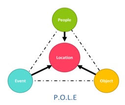
Sir Robert Peel, the founder of modern policing, claimed that the best measure of success in policing is the absence of crime. People in policing have a vocational desire to make a difference and prevent harm. To do that, we need insight. In policing, we use the four-step SARA model for problem-solving: Scan, Analyse, Respond and Assess. The scanning and analysis stages looking at the Victim, Offender, and Location triangle used to be fulfilled by professional analysts. However, too often, it was backwards-looking and out of date by the time it was completed, considered, as an end in itself as opposed to a crucial step to provide insight to smart policing.
The world has changed dramatically from my early years of service where records were kept on ‘collators cards’. As the world digitalised, data proliferated to levels measured in the millions daily, even for a medium-size police force like ours. When I became Chief Constable of Avon and Somerset Police, data was seen as a blizzard of risk, blinding officers and staff into risk aversion and inertia. We transformed the proliferation of data into an opportunity to "join the dots".
Harnessing and democratising this data to drive our decision making from the Boardroom to the Briefing Room, has, in my view, been, the most influential development of the last decade. Where do maps and mapping fit into all this? Well, people, be they victims, witnesses or suspects, along with objects and events all orbit place or location. Without the ability to identify the location, questions will always be unanswered, leading to analysis and solutions being ill-informed or suboptimal.
Location data helps keep the public safe
Thanks to the new Public Sector Geospatial Agreement (PSGA), launched in April 2020 by the Geospatial Commission, we are provided with an opportunity to future proof our use of location data. Prioritising access to the data, with the use of API technology, and making the data free at the point of use, is underpinning the effective and efficient delivery of our services, enabling innovation and insights to protect our citizens.
Our GeoServices team curates relevant geospatial datasets to integrate to or build applications. The more we can pull on a wide range of geospatial data, the richer our derived insight is.
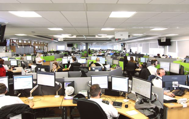
First and foremost, the Command & Control Mapping System, the “operation centre” behind every first response, is reliant on good geospatial datasets. Incidents are overlaid on the PSGA datasets and can be combined with open data, third party datasets (e.g. environment agency, network rail, etc). Once the caller has confirmed the incident location, staff visualise the environment and assess what action to take: are resources available nearby? Do roads need closing and traffic diverted?
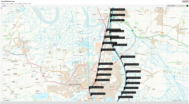
In the event of a high-speed chase, Command & Control (C&C) staff are on high alert: monitoring the situation, getting ready to send more resources, thinking ahead and predicting outcomes. Staff follow real-time development through GPS equipped police vehicles on their mapping system. Thanks to OS Basemaps, aerial photography, and the OS MasterMap Highways Network, they can coordinate responses and keep the public safe.
Location data enables innovation and new ways of working
In Avon & Somerset, we encourage our staff to try new techniques and ways of working and we pride ourselves on being innovators. Our data-driven revolution was driven by a fundamental question of public protection. How do we predict the risk of harm by an offender and the risk of vulnerability in a member of the community? What can we do to intervene early to prevent them from coming together in a place where harm may occur?
Where the magic really happens is when our geospatial and/or data analytics teams come together with practitioners, leading to the design of hundreds of bespoke applications solving real operational challenges. The applications are near real-time and available 24/7, 365 days a year. For example, one of our latest GIS-based applications was developed with the Offender Management Unit (OMU) to risk-assess the proposed address of offenders given upon prison release, using PSGA location datasets. This Geospatial data is of immeasurable value for assessing the community risk in certain conditions. Another one of my favourites is called ‘My Work’, a personal digital twin for every officer to stay abreast of their caseload, victim updates, data quality and so much more. I love the heat map of Officers’ patrol time!
With more and more data being available and mappable, the future is promising to be even more exciting. We welcome the new provision of PSGA data via an API this year, as this will mean the data will be more flexible, allowing our data requirements to evolve and to make use of the new ideas and opportunities offered by new and emerging technologies.
The data will be fed directly within our software (e.g. our Command & Control system mentioned above) enabling a timely and cost-effective use of data, freeing up the Geoservices team valuable time to develop further innovative products.
Location data helps shape a better future
As I write this blog, I’m coming to the conclusion of my ‘2021 Roadshows’ where I meet and speak to all of the people in the force who I have the privilege of leading and supervising. I use this opportunity to set the direction and share psychological ownership of the mission for the year ahead. We’ve done this remotely this year, of course, using innovative approaches to make it feel real and personal for everyone involved. An outstanding police service needs to pay attention to things that are traditional in policing, including teamwork, public service, dedication and values-based leadership. But that isn’t enough in the dynamic, complex and interconnected world we now live in. This is why we need to embrace and utilise the opportunities of data and digitalisation.
One of our organisation values is ‘Caring’, the ultimate professional advantage in policing. We need people to care about protecting victims of crime, the quality and impact of their work as well as the confidence that the community that we serve has in us. If this is the case, we need to demonstrate that we care about them too, both emotionally and practically. Practically, we need to pay attention to fixing the environment that our people operate in and that means giving them the right tools and technology to do the job.
It also means pushing the data to the workforce and giving them the authority and support to be empowered to do what is best to achieve our mission: Serve, Protect and Respect.
Like leadership, data is the glue that can keep us together, pulling in the same direction. My love of maps and my fascination with place, has been fused with my passion for policing. Geospatial technology is a capability that has linked the three and given us a “super accelerator” in our vision to provide outstanding policing for everyone.
Sign up to this blog to get an email notification every time we publish a new blog post.
1 comment
Comment by Mr Ian Foster posted on
Really interesting article. Love how we are using this technology to fight crime. I'm using the historical crime data from police.uk on my geospatial augmented reality platform. When smartglasses finally arrive you'll be able to see the crime hotspots around you. Can I tap into your historical heat map patrol data via the API? What will the API endpoint be? Thanks in advance