As Data Standards Lead at the Geospatial Commission I have been investigating species data and the path it takes from getting collected to being made available, to monitor species. Knowing a species geographic location is fundamental to many aspects of biodiversity conservation.
Annabelle Sampah - As lead, for the Housing and Planning Programme in the Geospatial Commission, I believe the opportunities are endless. However, early on in our investigations, we realised that it was quite difficult to get a good baseline view of what was happening across the sector and where further action could be taken to add value.
Geography and geospatial data have many applications to our lives including policing and public safety, a foundation of any democratic and progressive society.
In June last year, the Geospatial Commission published the UK Geospatial Strategy, which includes a commitment to ‘assess how location data can support the future of mobility and next-generation transport networks.’ Today, I’d like to provide an update on …
In this guest blog, Professor Heathwaite discusses how land use location data could help us make more joined-up decisions about land use to avert a collision course with our most valuable asset.
The National Archives is pleased to introduce the Developer Licence 2.0. As with the licence it replaces, it is part of the UK Government Licensing Framework (UKGLF) which provides the policy and legal framework for the re-use of public sector …
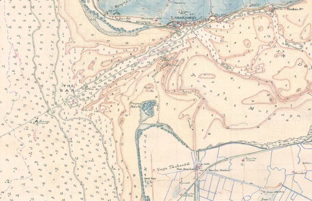
The Geospatial Commission and its Partner Bodies have collaborated to provide this Best Practice Guide: Extracting data from Archives. In these times of fast-paced change, our archive data which contains a rich layer of location data will become increasingly important, delivering value to the economy and wider society.
We’re delighted to kick-start our series of “international” blogs with a guest blog from David Henderson marking the 10th anniversary of the Committee of Experts and reporting back on three key tangible outcomes from the latest UN-GGIM virtual meeting held in August.
The Geospatial Commission wants to better understand how access to location data can support commercial innovation in mobility services. Dr Steve Unger will be chairing a new Transport Location Data Taskforce, which will bring together businesses interested in exploiting location data with key public sector organisations.
Did you know that the UK’s Geospatial Strategy is available to download in Welsh? The Geospatial Commission asked Dr Richard Fry, Senior Lecturer in Geography and Geographic Information Systems (GIS) at Swansea University Medical School, to shine a light on …