
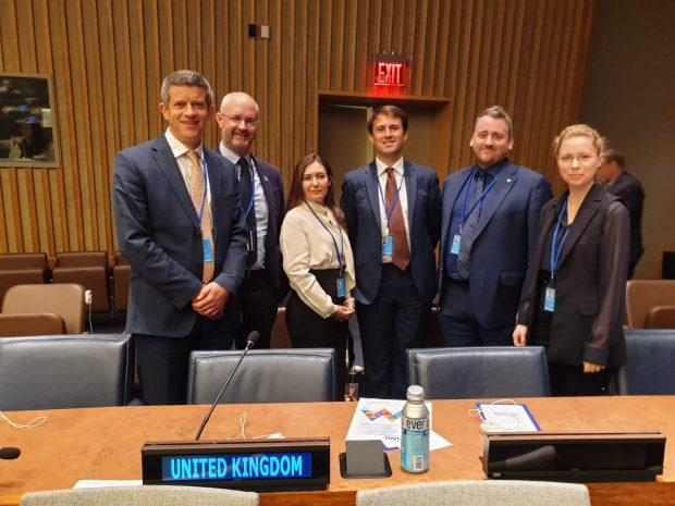
The UK has a long history of supporting global geospatial discussions and decisions. Our international commitments in the UK’s Geospatial Strategy show our ambition to continue to contribute on the international stage. Ordnance Survey is a key representative of the UK government in geospatial international fora, acting on behalf of the Geospatial Commission and in close partnership with other public sector bodies. David Henderson, OS’s Chief Geospatial Officer, leads the UK government delegation to the UN’s Committee of Experts on Global Geospatial Information Management (UN-GGIM) and is a Vice-Chair of the UN-GGIM: Europe Regional Group. The UN-GGIM Committee of Experts meets yearly to report on progress with regards to their defined mandates.
We’re delighted to kick-start our series of “international” blogs with a guest blog from David himself marking the 10th anniversary of the Committee of Experts and reporting back on three key tangible outcomes from the latest meeting held in August.
Geospatial information underpins a modern society. It improves quality of life by securing land rights or streamlining transportation to keep goods and services moving. It helps mitigate against, prepare for, respond to, and recover from disasters. And, linked with statistical data, it acts as a powerful tool to inform policy development and ensure effective public service delivery. UN-GGIM ensures that nations are working together. It helps develop and share best practice as well as ensuring that trusted and authoritative geospatial information is capable of supporting the forthcoming Decade of Action necessary to realise the targets set out by the Sustainable Development Goals.
In my role as the Head of Delegation to the UN-GGIM Committee of Experts and with the support of the Geospatial Commission who set the UK’s geospatial strategy and policy, we bring together geospatial leaders from across the public sector to ensure the UK government is well represented in the various UN-GGIM Expert and Working Groups. This includes the Office for National Statistics (Integration of Statistical and Geospatial Information), HM Land Registry (Land Administration and Management), UK Hydrographic Office (Marine Geospatial Information) and Ordnance Survey (Subcommittee on Geodesy, Geospatial Information and Services for Disasters, and the Integrated Geospatial Information Framework).
These groups are a valuable opportunity for UK organisations to contribute expertise to global discussions. They are also an important opportunity to learn from other nations and benefit from their international knowledge and experience, and to bring that learning back to the UK geospatial community.
This year has been significant for the UK:
In March 2020, the UK government hosted the Sixth UN-GGIM High Level Forum - an inspiring collection of discussions highlighting the critical role that location data is playing, now more than ever. If you missed the event, it’s worth catching up on the presentations and discussions attended virtually by almost 900 delegates from 95 countries!
In August, this year’s meeting of the Committee of Experts saw the adoption of three important topics, which are worth us all knowing about.
1. A Global Geodetic Centre of Excellence
Geodesy is the science of the shape of the earth and includes accurate positioning. Accurate positioning is essential for navigation systems, security, infrastructure, sustainable development and disaster management. It also helps us with environmental protection – making it possible to measure the thickness of glaciers and the change in sea-levels. In the UK we use geodesy in many ways, from traditional surveying and mapping applications to cutting-edge technological developments in agriculture and transport systems.
A persistent challenge is that global geodetic infrastructure is often coordinated on a ‘best efforts’ basis. A resolution for a Global Geodetic Reference Frame for Sustainable Development was adopted by the UN in 2015 to co-ordinate public geodetic infrastructure at a global level and deliver globally consistent benefits from accurate positioning.
Building on that UN Resolution, I was delighted that our colleagues in Germany have offered to fund and host the first Global Geodetic Centre of Excellence. This offer was unanimously accepted, and the Centre will be operational from 2021. UN Members have been invited to contribute to the Centre and we’re currently in dialogue as to the best way the UK can do so. If you’re interested in contributing, or would like to know more, please do get in touch.
2. Future Trends – looking to the future
By invitation of the Committee of Experts, the UK has led the development and publication of a series of reports looking at future developments in geospatial information. This year, under the leadership of my colleague Christin Walter, Ordnance Survey published the third edition of Future Trends in geospatial information management: the five- to ten-year vision.
It covers a wide range of insights (new data sources and analytical methods, technological advancements, and broader structural shifts) which will influence the longer-term direction of our industry. Many of these trends also underpin the UK domestic context and were incorporated into the UK’s Geospatial Strategy – both in the strategic focus of the Missions and the six key Location Data Trends. The report has been received with widespread acclaim as a valuable source of strategic insight by governments, industry, and global institutions to inform their organisational development and investment decisions and I’d encourage all geospatial professionals to be familiar with it!!
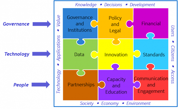
3. The Integrated Geospatial Information Framework
Proposals for an Integrated Geospatial Information Framework (IGIF) were initially developed in 2017 when the UN and the World Bank agreed, a joint vision to promote countries growth and prosperity. Delivered through a framework that can be applied to any country, no matter its level of development, to strengthen their geospatial capabilities. It is based on nine Strategic Pathways covering different aspects of geospatial maturity from governance to data to technology to people.
Adopting the Implementation Guide for IGIF paves the way for countries to develop their own Country-level Action Plans to establish, maintain, or improve their national systems and capabilities. The UK’s Geospatial Strategy adopts the IGIF, preparing for a new national location data framework consistent with its principles and I’m really looking forward to working with the Geospatial Commission and other key stakeholders to progress our adoption over the coming year.
Whilst always humbling to be part of such an important global initiative as UN-GGIM, I also find it a valuable opportunity to learn from others, and to help contribute the UK’s experiences and promote our collective expertise. The UK’s long-standing tradition of geospatial innovation and our focus on the economic contribution of effective geospatial infrastructure continues to be a source of inspiration for many other nations on the global stage.
To prepare the UK inputs to the annual Committee of Experts meeting, we convene a UK stakeholder group several times a year with representatives from central government departments and the Devolved Administrations, as well as civil society and industry. The group agrees how we best contribute to the annual work plan and participate in the global Working Groups. To find out more and see how your organisation can get involved in the future, please do get in touch.
Finally, look out for our short series of webinars in conjunction with the Geographers in Government Profession and the Association for Geographic Information where we’ll be sharing further updates about the work of UN-GGIM and the UK’s participation.
Follow this link to read more about the UK Geospatial Strategy.
Sign up to this blog to get an email notification every time we publish a new blog post.