By looking at licensing from the user perspective the Geospatial Commission and Geo6 have worked together to make data licensing and data more accessible.
Guest blog by Carl Watson, Senior Analyst and UX Lead, British Geological Survey who shares the steps taken to build a data portal for the user. “After listening to what real users want we have created guidelines for Designing Geospatial …
Guest blog: Howard Askew shares the benefits of the latest Data Improvement tool - List of Geospatial Data Publishers by theme or topic, and how it tackles two of the big challenges faced by users of geospatial data today.
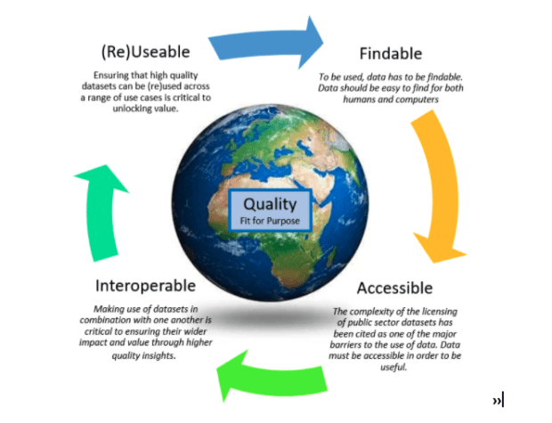
Callum Irving, Senior Data and Standards Advisor, shares the Geospatial Commission’s ambitions to improve access to better location data by making it Q-FAIR - Findable, Accessible, Interoperable, Reusable and of the right Quality that is fit for purpose. Building on …
Guest blog by Ada Lovelace Institute - The Geospatial Commission has partnered with Sciencewise, Traverse and the Ada Lovelace Institute in a new project that will open a dialogue with members of the public to gather evidence about their perspectives on the ethics of location data use.
As Data Standards Lead at the Geospatial Commission I have been investigating species data and the path it takes from getting collected to being made available, to monitor species. Knowing a species geographic location is fundamental to many aspects of biodiversity conservation.
Annabelle Sampah - As lead, for the Housing and Planning Programme in the Geospatial Commission, I believe the opportunities are endless. However, early on in our investigations, we realised that it was quite difficult to get a good baseline view of what was happening across the sector and where further action could be taken to add value.
The National Archives is pleased to introduce the Developer Licence 2.0. As with the licence it replaces, it is part of the UK Government Licensing Framework (UKGLF) which provides the policy and legal framework for the re-use of public sector …
The Geospatial Commission and its Partner Bodies have collaborated to provide this Best Practice Guide: Extracting data from Archives. In these times of fast-paced change, our archive data which contains a rich layer of location data will become increasingly important, delivering value to the economy and wider society.
We’re delighted to kick-start our series of “international” blogs with a guest blog from David Henderson marking the 10th anniversary of the Committee of Experts and reporting back on three key tangible outcomes from the latest UN-GGIM virtual meeting held in August.