
Coronavirus and geospatial data
Geospatial data has been used to identify causes of disease, track its spread and monitor the recovery of patients since the 19th century, when John Snow mapped cholera outbreaks in London in 1854.
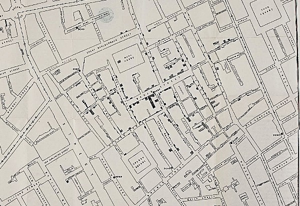
Image: Snow, J. On the Mode of Communication of Cholera, 2nd Edition, 1855.
With the development of new software and data collection technology, both the effects and the impacts of measures to track and manage diseases such as the current coronavirus pandemic can be monitored in near real-time, enabling improved responses, minimising the loss of life with geospatial data playing a central role.
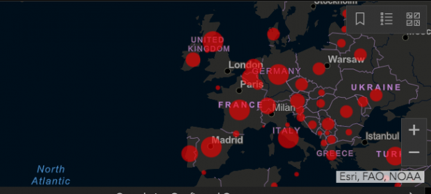
John Hopkins University COVID-19 Dashboard, displaying near real-time data from across the globe using ESRI technology
Geospatial data is currently being used to model the transmission of the virus, predict regions more likely to be vulnerable to its spread and identify the nearest healthcare and other key services needed in our communities. Existing real-time, location-based technology is being repurposed to support the national response such as the newly created NHS Volunteer Responders. This initiative uses a platform similar to other food and transport service providers to enable project coordinators to remotely assign tasks to individuals in the field depending on need and prioritisation. Already 750,000 volunteers have signed up to participate in the scheme.
The public sector is working with partners to see how data can best support the UK’s response. PUBLIC, a GovTech venture firm, launched a £500k programme with NHS-X to fund the development of 23 technology solutions that can support vulnerable individuals as a result of COVID-19. Projects will relate to remote social care, optimising the care system and mental health.
Boosting the coronavirus response with new licensing provisions
One way the Geospatial Commission is supporting the public sector to access improved geospatial data in the longer term is through its 10 year Public Sector Geospatial Agreement (PSGA), which was announced earlier this month ensuring the public sector has access to the Ordnance Survey’s world leading data.
In addition, the Ordnance Survey has been supporting a wide range of public bodies in its response to the coronavirus pandemic, underpinning decision making and helping to manage the crisis more effectively as part of its Mapping for Emergencies (MfE) service that supports the resilience community and is available free of charge 24 hours a day, every day of the year, at no cost – in any emergency.
However, the response to the coronavirus goes beyond the public sector with private sector organisations having a key role to play. To ensure that anyone can access its data during this unprecedented time, the Ordnance Survey has now released a new short term ‘Covid-19 licence’. The licence will enable organisations, developers and individuals to use OS data, free at the point of use, for the specific purpose of supporting the UK response to the coronavirus pandemic.
What does the licence offer?
The new licence enables access to a range of Ordnance Survey products, including detailed topographic data with OS MasterMap and Points of Interest information. It also provides access to addressing (including data from Royal Mail and Geoplace) and road datasets as well. This will enable users to:
- Use mapping data to visualise and provide context for third party data sets. E.g. mapping demographic data to allow users to recognise areas with an ageing population
- Create a web or mobile app with easy to use location data to support communities in keeping in contact, finding resources and sharing location information
- Identify and understand proximity of key services in specific areas. E.g. where is the nearest pharmacist
- Better plan allocation of scarce resources with new demand models with public sector organisations. E.g. transportation to hospitals
Users will be able to access Ordnance Survey premium data free of royalties until 30 September 2020. Users can access the temporary licence via the Ordnance Survey pages https://www.ordnancesurvey.co.uk/about/covid-19/new-to-os
How can you get involved?
Businesses and individuals across the world are now facing huge challenges. The impact of social distancing and self-isolation measures present both economic and practical challenges to a wide range of businesses and services, from delivery businesses to food manufacturers, entertainment, financial services, healthcare, hospitality, retail, transport and community support.
Innovate UK will be investing up to £20 million in business projects to develop innovative and ambitious ideas to significantly address the needs of society or industry resulting from the coronavirus outbreak. Businesses can attract up to £50,000 as an upfront grant payment to cover the full costs of a project lasting up to 6 months. Ideas should aim to help key industries and services disrupted by the pandemic and its aftermath. The competition closed on 17 April and the Geospatial Commission would be interested to hear if you have applied.
Innovation and collaboration are important for us all, not just in the UK, but globally, to respond and tackle the coronavirus pandemic together. The Geospatial Commission would like to thank those in the geospatial community from across the private, public, academic and civil society sectors for your support and service during these unprecedented times.
If you are successful in receiving a funding award through the Innovate UK scheme and geospatial data is central to the success of your proposal, or you applied and were not successful or you intend to use Ordnance Survey’s new licensing provisions please do get in touch via geospatialcommission@cabinetoffice.gov.uk
To find out more about how your organisation can offer support to the government please visit Crown Commercial Service pages.
1 comment
Comment by Valerie Thomas posted on
It would be interesting to map this geospatial data on covid-19 against the geospatial data on child poverty and ethnicity. It might also help prioritise any future covid-19 vaccination programme and allow planning of outreach services to specific groups to deliver such a programme. There is some limited experience in targeting specific ethnic groups in NHS cervical screening.
Dr Val Thomas PhD MBBS FRCPath (retired)