Development of new app will help democratise planning in London
We recently received funding from the Geospatial Commission for the development of an app that will enable anyone to see the buildings that are proposed in their area. The app will also allow them to comment on the plans. And it will provide access to a whole range of information about existing buildings – gathered from the public.
This will be a really significant step towards improving the way in which the general public in London can understand and participate in the planning process.
Geospatial data can help with the planning process
To deliver this project, VU.CITY is partnering with Colouring London, an initiative developed by the Centre for Spatial Analysis (CASA) at University College London. Colouring London is already gathering data on buildings across London in 12 categories – from location, age and size to materials, energy efficiency and whether it is a public asset.
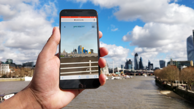
By working together, this crowdsourced data will be available as a 3D model, using VU.CITY’s existing platform within which the whole of Greater London is available as the most accurate 3D map in the world. The app, called YOUR.VU.CITY, will enable users to see a 3D version of any location in London from street level, from above, or from their office or bedroom window! By including schemes that have already been granted planning consent, the public will gain a real understanding about how their local area will change.
Growing, building and testing
Since we got the grant a few months ago, we have developed a properly structured team. Work is already underway at CASA developing an API which will allow the data held within Colouring London to be integrated with VU.CITY. This will be completed soon, and we’ll then begin the process of building and testing the app before its launch in the spring of next year.
A massive thank you to the Geospatial Commission for helping bring such an exciting partnership to life, and for taking a global lead on embracing the data revolution. For planning, we hope that this is just the start of a new and better approach to how the built environment is understood, and having access to even more open government data will help close the information gap between the public and the professionals.
Sign up to this blog to get an email notification every time we publish a new blog post.