Data
Guest blog: Howard Askew shares the benefits of the latest Data Improvement tool - List of Geospatial Data Publishers by theme or topic, and how it tackles two of the big challenges faced by users of geospatial data today.
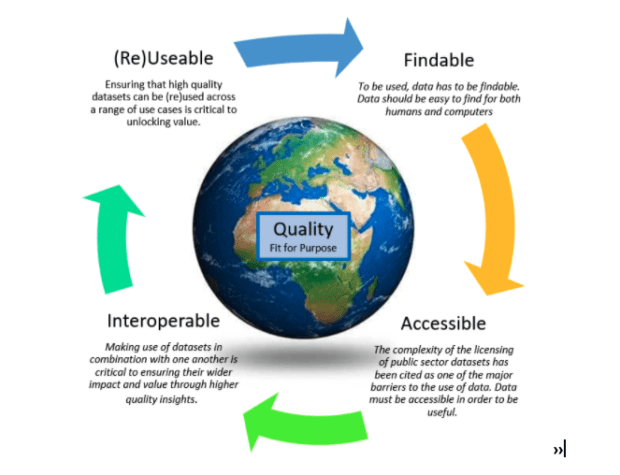
Callum Irving, Senior Data and Standards Advisor, shares the Geospatial Commission’s ambitions to improve access to better location data by making it Q-FAIR - Findable, Accessible, Interoperable, Reusable and of the right Quality that is fit for purpose. Building on …
Guest blog by Ada Lovelace Institute - The Geospatial Commission has partnered with Sciencewise, Traverse and the Ada Lovelace Institute in a new project that will open a dialogue with members of the public to gather evidence about their perspectives on the ethics of location data use.
As Data Standards Lead at the Geospatial Commission I have been investigating species data and the path it takes from getting collected to being made available, to monitor species. Knowing a species geographic location is fundamental to many aspects of biodiversity conservation.
Jamie Clark, Deputy Director (Commercial) at the Geospatial Commission, provides an overview of how the Public Sector Geospatial Agreement (PSGA), that has been in place between the Geospatial Commission (GC) and Ordnance Survey (OS) since April 2020, has been delivering …
Annabelle Sampah - As lead, for the Housing and Planning Programme in the Geospatial Commission, I believe the opportunities are endless. However, early on in our investigations, we realised that it was quite difficult to get a good baseline view of what was happening across the sector and where further action could be taken to add value.
Geography and geospatial data have many applications to our lives including policing and public safety, a foundation of any democratic and progressive society.
In June last year, the Geospatial Commission published the UK Geospatial Strategy, which includes a commitment to ‘assess how location data can support the future of mobility and next-generation transport networks.’ Today, I’d like to provide an update on …
Unlocking the value of geospatial technology requires developing more people with the right skills to work with location data, across organisations and sectors, to meet the UK’s future needs and support global development. The Geospatial Commission is collaborating with a …
In this guest blog, Professor Heathwaite discusses how land use location data could help us make more joined-up decisions about land use to avert a collision course with our most valuable asset.