
In December 2021 the Geospatial Commission published a blog highlighting the importance of location data, why it is so difficult to value, and the Geospatial Commission’s commitment to publishing guidance on how to measure the economic, social and environmental value of location data investments in the public sector. This commitment was first announced in the UK’s Geospatial Strategy and reiterated in our 2022/23 Annual Plan.
The Geospatial Commission commissioned Frontier Economics to support the development of a practical framework for appraising these benefits. Over the past several months, the project consolidated experiences and expertise across the private and public sectors in order to produce a framework that is both proportionate and consistent with Green Book. The Green Book is HM Treasury’s guidance on how to appraise policies, programmes and project principles and is a prerequisite for public sector investments to secure funding.
The guidance, published on 4 August, provides a structured approach to measuring and assessing the economic, social and environmental benefits associated with geospatial data investments in the public sector when building a business case, including improvements to the data and/or the wider geospatial ecosystem. Whilst this guidance focused on data investments in the public sector context, we hope the guidance will also be useful to the private sector for future investments in the geospatial ecosystem.
The approach
To understand the different types of geospatial data investments and the existing methods of valuation, the research involved a targeted but wide-ranging evidence and literature review. To complement this review, the project interviewed a range of geospatial data holders and users from across the public and private sectors, inviting them to share their experiences of using and supplying location data. These interviews helped to identify the key geospatial data characteristics that drive value and potential use cases.
As highlighted in our previous blog, there are inherent challenges with valuing location data:
- The value of location data is realised when combined with other datasets
- Value differs depending on the intended uses of the data
- There are a wide array of valuation approaches for data, but most do not routinely capture the benefits that spillover to others in society
To help address these challenges, a seven-step framework was developed that provides the tools necessary to consistently and coherently understand and assess the value of location data, including best practice approaches. The guidance acknowledges where there are dependencies and notes the importance of “difficult to quantify” benefits from location data investments, for example, increasing access to data could lead to more experimentation and positively impact innovation, benefits of which are notoriously tricky to foretell, though in some cases, can be more important than other benefits that are easier to quantify.
We also published four case studies demonstrating the approach taken to assessing value of previous geospatial investments, representing a diverse range of interventions, impacts and valuation methods. The case studies cover:
- National Underground Asset Register (NUAR)
- Public Sector Geospatial Agreement (PSGA)
- Transport for London’s (TfL) Open Data initiative
- HM Land Registry’s (HMLR) Data Valuation model
The Framework
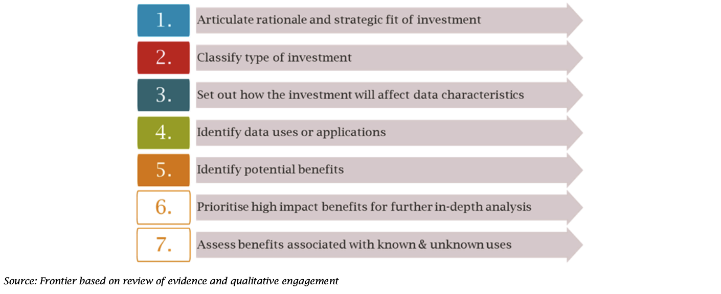
The seven-step framework provides users with a way of capturing value whilst maintaining analytical rigour and integrity.
Figure 1: Step-by-step framework for benefit appraisal
The approach set out in the guidance is referred to as the “use-case approach” which is intended to estimate value based on the different applications affected by the geospatial investment. In lieu of quantifiable benefits, a strong narrative and logical reasoning becomes a more crucial element of the case for investment.
Overall, the seven steps within the framework should provide decision-makers with a richer picture of how the investment will affect the geospatial ecosystem, specific groups of stakeholders and society more widely. This should ultimately help achieve greater consistency in approaches used to value geospatial data across the public sector.
The first five steps involve the development of a conceptual theory of change (see figure 2 below). Step 1 articulates the rationale behind the intervention and Step 2 classifies the investment to identify potential gaps or overlaps in intended impact.
Step 3 links the investment to specific data characteristics (if relevant) to determine drivers of change to potential applications and uses. This step is key to understanding the value of a geospatial data asset, as its value is dependent on its characteristics and intended use. Any investment could alter one or more characteristics which affect the potential applications of the data and therefore its value.
Steps 4 and 5 are used to identify applications, use cases and potential benefits. To complement this step, the guidance is accompanied by examples of use cases associated with various geospatial datasets as well as more detailed use cases from organisations that have previously made geospatial investments.
By developing a theory of change (and conducting a Q-FAIR Assessment), organisations can begin to understand and demonstrate what impact their investment will have on use cases.
Figure 2: Theory of Change for geospatial data investments
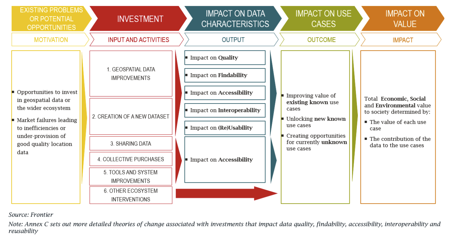
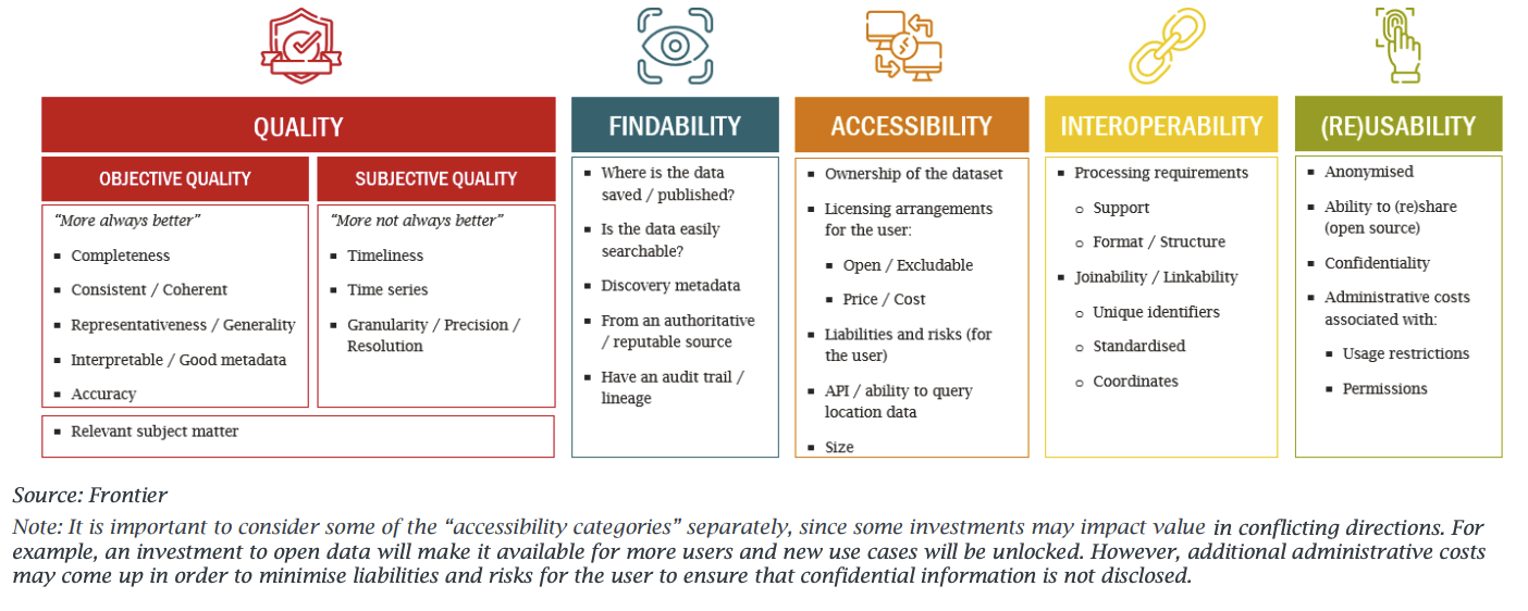
Figure 3: Q-FAIR assessment
Steps 6 and 7 conclude the framework by relating to the empirical and/or qualitative assessment, quantification and monetisation of the benefits identified in the theory of change. The combination of these steps should provide a comprehensive approach to measuring and assessing the economic, social and environmental benefits associated with geospatial data investments.
We would be keen to hear from organisations that put this framework into practice, if you have used this framework then please get in touch with us at geospatialcommission@cabinetoffice.gov.uk.
You can also sign up to get an email notification every time we publish a new blog post. For more information about this and other news see our website, or follow us on Twitter and LinkedIn.